Groundwater level measurement
Groundwater is one of the greatest treasures of Croatia, but in geotechnics it often causes great problems when excavating open pits. In the Republic of Croatia, about 90% of drinking water is in the form of groundwater. To better understand the processes related to groundwater, long-term (one year minimum) monitoring of groundwater levels is necessary.
The results of groundwater level measurements indicate the influence of sea tides on groundwater levels, the rate of aquifers response to rainfall, and the changes in water levels of rivers and lakes. The measurement results are later used for geotechnical and hydrogeological calculations and represent an important input for design.

Description of measurement and measuring equipment
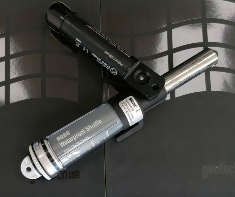
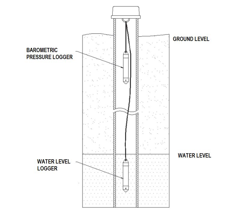
Groundwater level measurement and simultaneous water temperature measurement are performed by placing microprocessor based automatic water level loggers. Loggers measure the temperature and water pressure above the instrument. They are hung on a rope of appropriate length, depending on the depth of the piezometer or well. Possible measurement intervals range from 1 second to 18 hours and are selected depending on the project type and the duration of the groundwater level measurement.
When performing a slug test or a pneumatic slug test (PST), it is necessary to measure the groundwater level at the shortest possible intervals (1 second intervals minimum). When performing test pumping, it is enough to measure the groundwater level every minute. The interval for groundwater levels measurement during long-term monitoring ranges from 1 hour to 12 hours.
There are two versions of loggers, open and closed. With the closed version of the logger, it is necessary to add a barometric logger that measures the atmospheric pressure at the same intervals as the logger for groundwater level measurement. The barometric logger data is used for barometric compensation that is performed after the measurement. With the open version of the logger, a barometric logger is not required because the logger for groundwater level measurement has a built-in barometric pipe on the surface which automatically performs barometric compensation.

When groundwater levels measurement is taken near the sea, river or lake, it is necessary to measure electrical conductivity. This measurement is performed in order to determine the degree of water mineralization, i.e., to determine the impact of rivers, lakes and especially the sea on groundwater. The types of water according to their electrical conductivity values are shown in the table below.

Analysis of results
The collected measurement data are processed tabularly and graphically using HOBOware Pro software and Excel. When analyzing the results, it is necessary to take into account the data on daily rainfall in the studied area. We either download data on daily rainfall from the official website of the Croatian Meteorological and Hydrological Service or we measure them using an automatic rain gauge station. Below are two examples of groundwater level measurement where the impact of sea tides and rainfall may be seen.
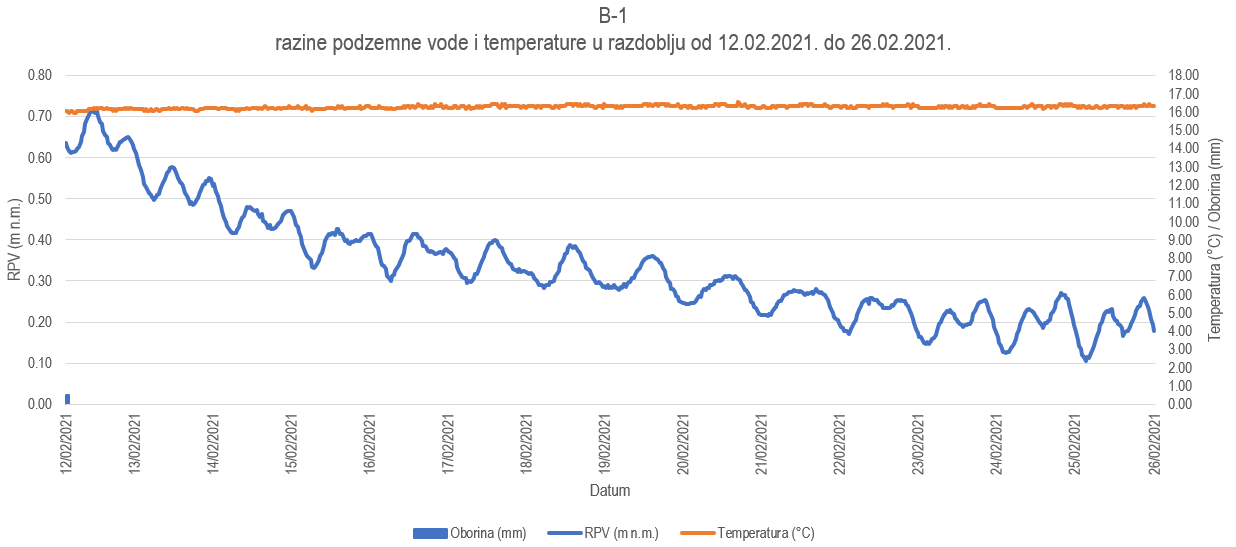
The impact of sea tides on groundwater levels can be significant and mostly depends on the permeability of the deposits and the proximity of the shoreline. The graph below shows the groundwater level, rainfall and groundwater temperature. The graph demonstrates the fluctuation of groundwater level from 5 to 20 cm due to the tides in the period without significant rainfall.

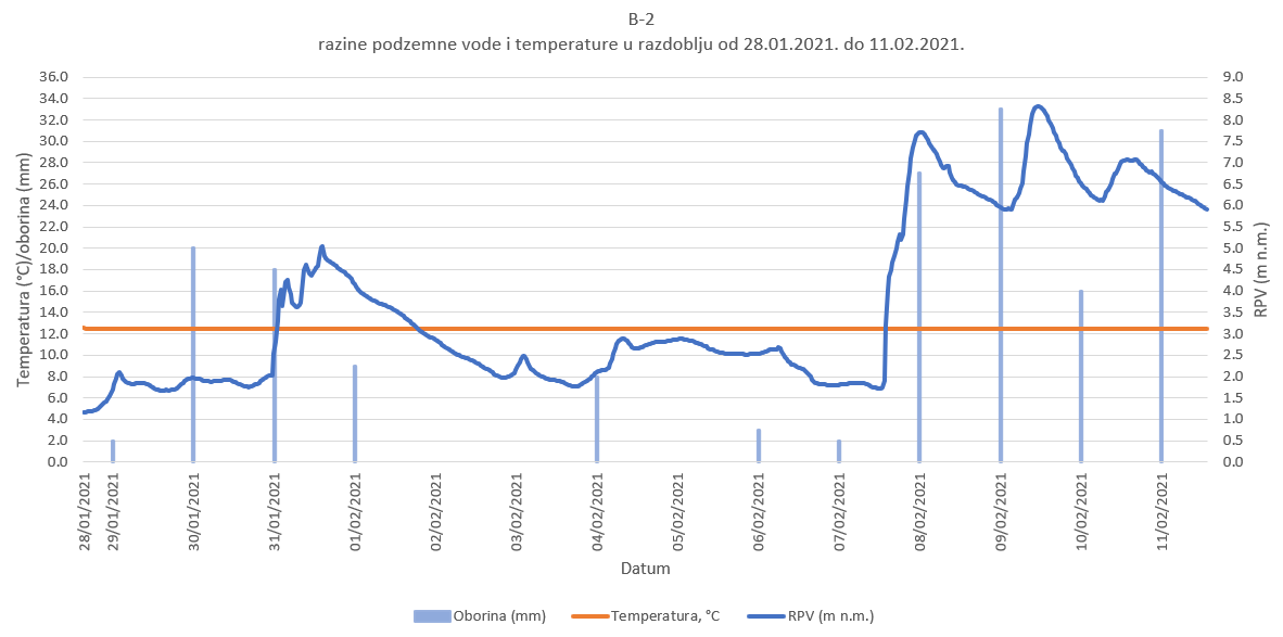
The water levels of large rivers (Sava, Drava, Dunav) have the greatest impact on groundwater levels in the Pannonian part of Croatia. In the karst part of Croatia, rainfall has the greatest impact on groundwater levels. The graph below shows the impact of rainfall on the groundwater level in the karst. The graph demonstrates that the aquifer reacts relatively quickly to rainfall that falls on its water catchment area. We recorded a sharp rise in groundwater levels due to a large inflow of groundwater from the hinterland on 8.2.2021. The groundwater level rose by approximately 6.0 m in 8 hours, and this confirms the relatively rapid response of the karst aquifer.

Conclusion
Our team of geologists actively conducts groundwater level measurement services in the Republic of Croatia and beyond. We use several devices to reliably measure the level and characteristics of groundwater at the microlocation. The measurement results provide us with an insight into the dynamics of groundwater, especially in karst terrains.
The construction of the future structure must be able to bear all the loads from the surrounding soil during the operation of the facility. Given the occurrence of groundwater at the site and due to its activity, it is necessary to calculate and dimension the structure with regards to the effect of buoyancy during and after the construction. The implementation of groundwater levels measurement and experimental pumping enables us to design the project for the protection of construction pits and foundations better.
Read more: Permeability test – Lugeon test, How to determine number and depth of exploration boreholes?
